IDN36501
Wednesday 29 April 2015
FLOOD WATCH FOR THE NEW SOUTH WALES COASTAL VALLEYS FROM THE QUEENSLAND BORDER TO TAREE FOR THIS FRIDAY AND SATURDAY
IDN36501
Australian
Government Bureau of Meteorology New South Wales
FLOOD WATCH FOR THE NEW SOUTH WALES COASTAL VALLEYS FROM THE
QUEENSLAND BORDER TO TAREE FOR THIS FRIDAY AND SATURDAY
Issued at 11:52 am EST on Wednesday 29 April 2015
##
Note: This
Flood Watch is a "heads up" for possible future flooding along all
rivers and creeks within a nominated valley and is NOT a Flood Warning [see
note below].
Onshore
winds and rain will increase as a trough deepens off the northern NSW coast on
Thursday and Friday. Another East Coast Low is expected to form within this
trough on Saturday near the QLD border before moving south to be offshore of
the Mid North Coast on Sunday. The northern half of the coast (Mid North Coast
and Northern Rivers) will receive the heaviest rain with multi-day falls of
150-200mm, locally 350+mm from Wednesday night to Saturday. Friday and Saturday
will see the heaviest widespread falls.
At this
stage there is a greater than 70% chance of flooding in the following river
valleys developing during Friday and Saturday:
1. Tweed
River valley - moderate to major flooding
2.
Brunswick River valley - moderate to major flooding
3.
Richmond and Wilsons River valley - moderate to major flooding
4.
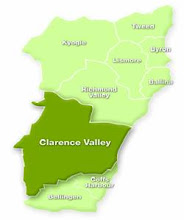
Clarence River Valley, including the Orara River - minor to moderate flooding
5. Coffs
Harbour - minor to moderate flooding
6.
Bellinger and Kalang River valley - moderate to major flooding
7.
Nambucca River valley - moderate to major flooding
8. Macleay
River valley - minor to moderate flooding
9.
Hastings River valley - minor to moderate flooding
10. Camden
Haven valley - minor to moderate flooding
11.
Manning River Valley, including Gloucester - minor to moderate flooding
There is
still the possibility of renewed flooding in the Hunter Valley (including the
Paterson and Williams Rivers) on Sunday and Monday. This will be reviewed on
Thursday based on the latest information.
This Flood
Watch means that people living or working along rivers and creeks must monitor
the latest weather forecasts and warnings and be ready to move to higher ground
should flooding develop. Flood Warnings will be issued if Minor Flood Level is
expected to be exceeded at key sites along the main rivers for which the Bureau
of Meteorology provides a flood warning service. Across NSW over 70% of Flood
Watches are followed by flooding within the catchment.
FloodSafe
advice is available at www.ses.nsw.gov.au
For
emergency assistance call the SES on telephone number 132 500.
For life
threatening emergencies, call 000 immediately.
Weather Forecast:
For the
latest weather forecast see www.bom.gov.au/nsw/forecasts/
Next Issue:
This Flood
Watch will be renewed by 11am Thursday morning.
Labels:
flooding,
NSW North Coast,
weather
Subscribe to:
Post Comments (Atom)


No comments:
Post a Comment